National Flood Insurance Program
For resources after a flood, please review the "After the Flood" booklet for specific contact in South Dakota. Please note: This booklet is not a complete list of resources; nor does it imply endorsement of any particular resource by the State of South Dakota.
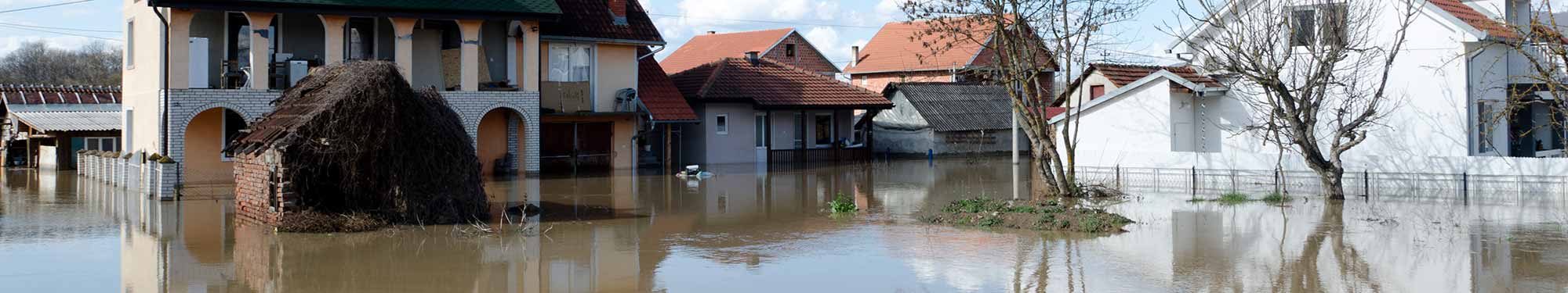
Floods continue to be a destructive natural hazard in South Dakota. Since 1978, flood insurance policy holders have received over $59.9 million in claim payments.
Individual Flood Insurance
Traditional insurance policies and disaster grants do not cover most losses, and repayment of a disaster loan can cost much more than a flood insurance policy.
Unfortunately, it's only after a flood that many people discover this. Approximately 25% of all flood damages occur in low risk zones, commonly described as being outside the mapped flood zone.
Every homeowner, business owner and renter in a community that participates in the NFIP may purchase a flood insurance policy. Enter your address in FEMA’s interactive flood hazard map to find flood documents and where the nearest flood hazard zone is located.
For Communities: Participation in the NFIP
To participate in the NFIP, a community must submit an application to FEMA, which includes a resolution of intent passed by the city council or county board stating that the community will act in good faith to regulate future floodplain development and an adopted floodplain management ordinance which meets minimum federal standards. Municipal or county governments establish community eligibility separately for incorporated and unincorporated areas.
Community participation in the NFIP is divided into two phases, the Emergency Phase and the Regular Phase.
Emergency Phase
The Emergency Program is the initial phase of a community's participation within the National Flood Insurance Program (NFIP) if no flood hazard information is available or the community has a Flood Hazard Boundary Map (FHBM), but no Flood Insurance Rate Map (FIRM). Upon NFIP application approval, a limited amount of flood insurance coverage at less than actuarial rates are available for all residents of the community.
Under the NFIP, communities are required to adopt minimum floodplain management standards to control future use of its floodplains. Studied communities are provided a FIRM with identified flood risk zones by FEMA. Local communities are given six months to adopt the flood maps into their local zoning and building code ordinances. If flood insurance maps are not adopted by the local community, federal flood insurance will not be available in either phase of the NFIP.
Regular Phase
After NFIP application approval, completion of a Flood Insurance Study, issuance of a FIRM, and adoption of floodplain management standards, communities will then be placed into the Regular Program. Under the Regular Program of the NFIP, comprehensive floodplain management requirements are required of the community but higher amounts of flood insurance coverage will be provided by FEMA.
Local officials may request floodplain map updates, as needed. FEMA processes and evaluates these requests; and subsequently issues revised maps and/or determinations.
Flood Insurance Resources
For more information about the NFIP, ask your insurance agent or call the NFIP at 1-800-611-6123.
Flood Insurance Plan FAQs
The community is not required to participate in the National Flood Insurance Program (NFIP) to receive funds for hazard mitigation plans; however, to be eligible for future Hazard Mitigation Assistance funds for specific mitigation projects identified in the plan, the community must join the NFIP and maintain good standing, but this requirement only applies if the project is located within the Special Flood Hazard Area (SFHA).
-
Adopt and enforce a flood damage prevention ordinance.
- Require permits for all types of development in the floodplain.
- Assure that building sites are reasonably safe from flooding.
- Estimate flood elevations where not determined by FEMA.
- Require new or substantially improved homes and manufactures homes to be elevated above the Base Flood Elevation.
- Require non-residential buildings to be elevated or flood-proofed.
- Determine if damaged buildings are substantially damaged.
- Conduct field inspections and cite violations.
- Require Elevation Certificates to document compliance.
- Carefully consider requests for variances.
- Resolve non-compliance and violations.
- Advise FEMA when updates to flood maps are needed.
Enrollment in the National Flood Insurance Program is initiated by a voluntary agreement between the local jurisdiction and the federal government. It is agreed that if a community implements and enforces measures to reduce the risk from flooding in special flood hazard areas, the federal government will make flood insurance available within the community to mitigate future flood losses.
There are nearly 200 communities participating in the NFIP in South Dakota. Visit FEMA’s Community Status Report for a list of communities.
Letter of Map Amendment (LOMA): This is used to revise the SFHA boundary based on detailed elevation surveying and/or topographic mapping of natural conditions. If the home site and the lowest flood of the building (including basement or garage) is above the BFE, we can amend the map to remove the home site and other land area from the SFHA. Thus mandatory flood insurance purchase is lifted.
Letter of Map Revision (LOMR): This is used for new detailed flood studies, drainage improvements, channel alterations, etc., where the boundaries of the SFHA are altered.
To apply for a LOMA or LOMR, a MT-EZ application form must be completed and submitted for an individual residential lot LOMR or LOMA. Multi-lots and major LOMRs are submitted on MT-1 or MT-2 applications. All are processed in Washington, D. C. There are fees for these. Forms are available through FEMA.
Most people think they can’t get flood insurance, but every homeowner, business owner and renter in a community that participates in the NFIP may purchase a flood insurance policy. In fact, 25% of all flood damages occur in low risk zones, commonly described as being outside the mapped flood zone.
Enter your address in FEMA’s interactive flood hazard map to find flood documents and where the nearest flood hazard zone is located. Then talk to your insurance agent about plan options.